Showing posts with label USGS. Show all posts

Saturday, October 15, 2022

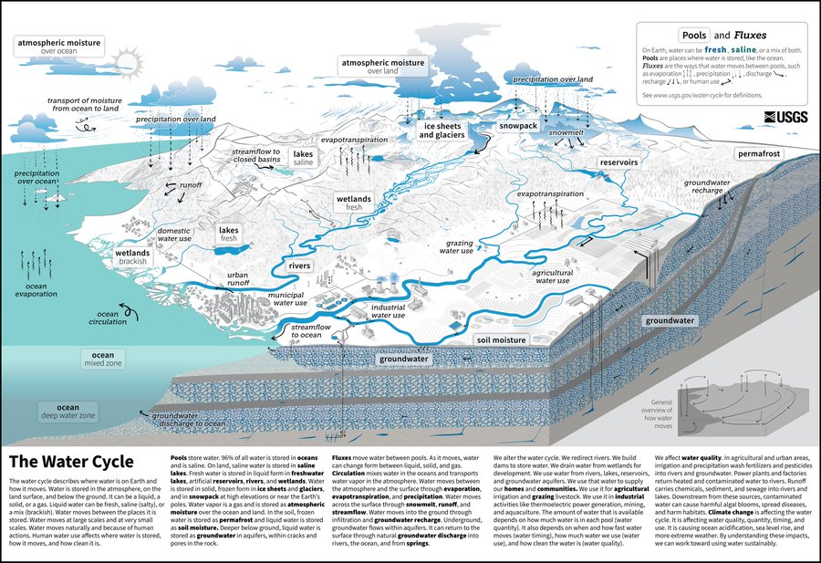
"the global water cycle ... how human water use affects where water is stored, how it moves, and how clean it is"

Daniel Moser (@_dmoser) tweeted on Fri, Oct 14, 2022:
๐ŸŒŠThe new Water Cycle๐ŸŒŠ

Although people have long siphoned water from groundwater and diverted rivers into farm fields and industrial plants, this new diagram is the first time humans have been included in what was presented until now as a "natural" cycle by @USGS ๐Ÿ‘‡๐Ÿ‘‡ 
https://t.co/ABJobxNRQ6

Shared from Twitter -> https://twitter.com/_dmoser/status/1580930320701919232

The updated water cycle

Sunday, June 14, 2020

Updated USGS digital topographic maps feature more trails


"As we approach summer, President Trump has designated the month of June as “Great Outdoors Month” and USGS maps are the perfect resource as you head outside and explore. Updated US Topo maps and other mapping products now make the planning and navigation of your next outing easier. Recent partnerships with other federal, state, and non-governmental organizations have allowed the USGS to feature additional trails and major recreation points of interest on our digital topographic maps.

Collecting Trail Data From Partners

The USGS has become an aggregator of national trails and recreational features. The National Geospatial Program (NGP) at the USGS has been seeking and leveraging partnerships with other agencies and organizations by making their data available through USGS mapping products and services. These contributions and collaborative efforts have resulted in the addition of more than 210,000 miles of government maintained trails to the Nation’s topographic base maps."
Continue reading the article online
https://www.usgs.gov/news/usgs-maps-will-help-you-explore-great-outdoors

US Topo maps
https://www.usgs.gov/core-science-systems/national-geospatial-program/us-topo-maps-america

Updated USGS digital topographic maps feature more trails

Monday, April 27, 2020

U.S. Geological Survey introduces "Learning From Home" portal

The U.S. Geological Survey Youth and Education in Science (YES) Team has revamped their web presence to better assist with online and home learning.

Check the new USGS Learning From Home portal for weekly lesson plans and activities, grades K – 12.

Students of all ages can always tap into the USGS Resources for Teachers for over 140 years of USGS research in the natural sciences in the form of lesson plans and activities, maps, podcasts, online lectures, videos and animations, and much more. Browse thousands of ideas for using these resources in elementary, secondary, university, and informal education settings.

  • USGS Learning From Home portal   
https://www.usgs.gov/science-support/osqi/yes/resources-teachers/learning-home

  • USGS Resources for Teachers
https://www.usgs.gov/science-support/osqi/yes/resources-teachers/


https://edits.nationalmap.gov/tnmcorps/