Miss. Lily invites Kiddos 6-12 to make a Mini Masterpiece!The First of a NEW monthly open play group for Mahjong this week!Learn how to report weather to NOAA and help plan for prevention!Don't forget to adopt a fuzzy reading buddy!
Providing accurate and timely information about what matters in Franklin, MA since 2007. * Working in collaboration with Franklin TV and Radio (wfpr.fm) since October 2019 *
Sunday, April 26, 2026
What's happening at the Franklin Public Library during the week of April 27 ???
Sunday, May 11, 2025
Hurricane names for storms in 2025
"Since 1953, Atlantic tropical storms had been named from lists originated by the National Hurricane Center. They are now maintained and updated by an international committee of the World Meteorological Organization. Here is the list of names for the Atlantic basin in 2025."
 |
| Hurricane names for storms in 2025 |
Friday, November 8, 2024
Boston Globe: "Drought reaches ‘critical’ level in Massachusetts"
"The latest drought reports released Thursday show the severe drought in Massachusetts has reached a “critical” phase and is worsening, expanding beyond Greater Boston to now include central and western portions of the state, due to a lack of any significant rainfall. Rhode Island, Maine and Connecticut are also experiencing increased drought conditions.“Severe drought” conditions now exist in eight counties or about 32 percent of the state, up from 14 percent just last week, according to the US Drought Monitor.“Most stream flow rates across interior Southern New England are below normal or at their all-time lowest,” said Matthew Belk, lead meteorologist with the National Weather Service in Norton."
https://www.bostonglobe.com/2024/11/07/metro/massachusetts-drought-worsens-new-england/
 |
| https://www.drought.gov/states/massachusetts |
"The U.S. Drought Monitor depicts the location and intensity of drought across the country. The map uses 5 classifications: Abnormally Dry (D0), showing areas that may be going into or are coming out of drought, and four levels of drought (D1–D4). The map is jointly produced by the National Oceanic and Atmospheric Administration, U.S. Department of Agriculture, and National Drought Mitigation Center. Authors from these agencies rotate creating the map each week, using both physical indicators and input from local observers.This map is used by the U.S. Department of Agriculture to trigger some disaster declarations and loan eligibility. Individual states and water supply planning may use additional information to inform their declarations and actions. "
Learn more ->https://droughtmonitor.unl.edu/About/WhatistheUSDM.aspx
Tuesday, June 4, 2024
From Memorial Day to Hurricane Season, we get into climate impacts including spaghetti models (audio)
FM #1225 = This is the Franklin Matters radio show, number 1225 in the series.
This session of the radio show shares my conversation with Ted McIntyre, Franklin resident and climate activist. We met to record via the Zoom conference bridge on Tuesday, May 28, 2024.
We continued making sense of climate by working our way from Memorial Day weekend, the start of summer, and the hurricane season which is possible to be one of the most active. The warmth of the Atlantic Ocean is a key contributor to hurricane development.
This discussion continues our journey understanding the MA roadmap toward net zero and while it helps me “make sense of climate”, we hope it helps with your understanding as well.
If you have climate questions or Franklin specific climate questions, send them in and we’ll try to answer them in a future session.
The conversation runs about 32 minutes. Let’s listen to my conversation with Ted.
Audio file -> https://franklin-ma-matters.captivate.fm/episode/fm-1225-making-sense-of-climate-45-05-28-24--------------
Note: The Hurricane Season is June 1 through November 30. I think I said October 1, so I was off a few weeks.
Hurricane forecast from NOAA -> https://www.noaa.gov/news-release/noaa-predicts-above-normal-2024-atlantic-hurricane-season
Record breaking heat in Atlantic Ocean -> https://yaleclimateconnections.org/2024/05/what-you-need-to-know-about-record-breaking-heat-in-the-atlantic/
Hydrogen powered boat https://www.bostonglobe.com/2024/05/20/metro/hydrogen-powered-boat-in-boston/
Wildfire season starting earlier, lasting longer https://www.nbcnews.com/science/environment/wildfire-seasons-are-starting-earlier-getting-longer-rcna142231
Spaghetti model -> https://www.cyclocane.com/ewiniar-spaghetti-models/
** See the page that collects all the “Making Sense of Climate” episodes -> https://www.franklinmatters.org/2022/02/making-sense-of-climate-collection.html
--------------
We are now producing this in collaboration with Franklin.TV and Franklin Public Radio (wfpr.fm) or 102.9 on the Franklin area radio dial.
This podcast is my public service effort for Franklin but we can't do it alone. We can always use your help.
How can you help?
If you can use the information that you find here, please tell your friends and neighbors
If you don't like something here, please let me know
Through this feedback loop we can continue to make improvements. I thank you for listening.
For additional information, please visit www.franklin.news/ or www.Franklinmatters.org/
If you have questions or comments you can reach me directly at shersteve @ gmail dot com
The music for the intro and exit was provided by Michael Clark and the group "East of Shirley". The piece is titled "Ernesto, manana" c. Michael Clark & Tintype Tunes, 2008 and used with their permission.
I hope you enjoy!
------------------
You can also subscribe and listen to Franklin Matters audio on iTunes or your favorite podcast app; search in "podcasts" for "Franklin Matters"
"NOAA predicts above-normal 2024 Atlantic hurricane season"
"NOAA National Weather Service forecasters at the Climate Prediction Center predict above-normal hurricane activity in the Atlantic basin this year. NOAA’s outlook for the 2024 Atlantic hurricane season, which spans from June 1 to November 30, predicts an 85% chance of an above-normal season, a 10% chance of a near-normal season and a 5% chance of a below-normal season.NOAA is forecasting a range of 17 to 25 total named storms (winds of 39 mph or higher). Of those, 8 to 13 are forecast to become hurricanes (winds of 74 mph or higher), including 4 to 7 major hurricanes (category 3, 4 or 5; with winds of 111 mph or higher). Forecasters have a 70% confidence in these ranges.The upcoming Atlantic hurricane season is expected to have above-normal activity due to a confluence of factors, including near-record warm ocean temperatures in the Atlantic Ocean, development of La Nina conditions in the Pacific, reduced Atlantic trade winds and less wind shear, all of which tend to favor tropical storm formation."
Sunday, May 5, 2024
Hurricane season approaches, is your name on this list?
"What do the names Beulah, Andrew, Camille, Felix, Katrina and Hugo all have in common? They were all names given to some of the most deadly and destructive hurricanes in US weather history and whose names have since been retired.Over the years, new names have been added in their place and still many others have emerged as candidates for lists maintained by the World Meteorological Organization (WMO). The 2024 Atlantic hurricane season officially starts June 1 and this year is forecast to be an exceptionally active season."
Alberto BerylChris DebbyErnesto FrancineGordon HeleneIsaac JoyceKirk LeslieMilton NadineOscar PattyRafael SaraTony ValerieWilliam
 |
| National Hurricane Center |
Thursday, January 11, 2024
NOAA Climate.gov: "Climate change rule of thumb: cold "things" warming faster than warm things"
Climate change rule of thumb: cold "things" warming faster than warm things.
- Colder places are warming faster than warmer places.
- Colder seasons are warming faster than warmer seasons.
- Colder times of day are warming more than warmer times of day.
https://t.co/S28VYdqpLY
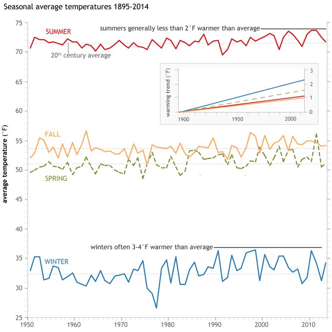 |
| Climate change rule of thumb: cold "things" warming faster than warm things |
Wednesday, December 6, 2023
New Blog from NOAA Climate.gov on the #PolarVortex
"We are excited to announce the new #PolarVortex Blog where we plan to explore various facets of the winds, #climate, and chemistry within this fascinating region of the atmosphere.
Our first post is HOT off the press:
https://t.co/gZOmT9A3ss"
Shared from -> https://twitter.com/NOAAClimate/status/1732155988671664570
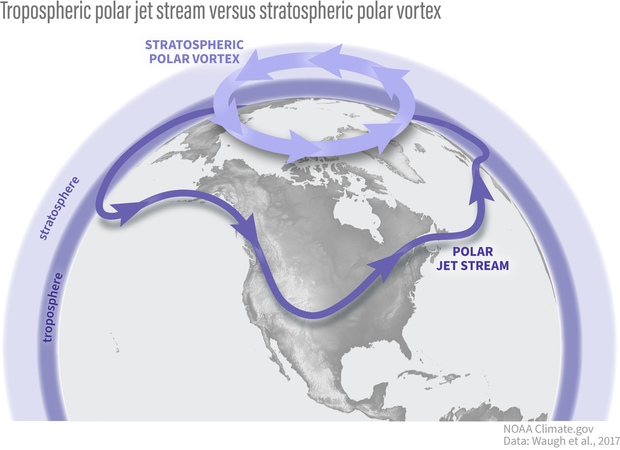 |
| stratospheric polar vortex |
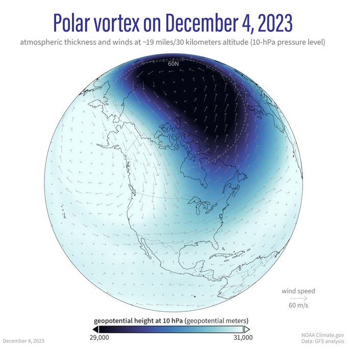 |
| Polar Vortex on Dec 4, 2023 |
Wednesday, September 27, 2023
El Nino could be super
"A fast-forming and strengthening El Niño climate pattern could peak this winter as one of the most intense ever observed, according to an experimental forecast released Tuesday. The new prediction system suggested it could reach top-tier “super” El Niño strength, a level that in the past has unleashed deadly fires, drought, heat waves, floods and mudslides around the world.This time, El Niño is developing alongside an unprecedented surge in global temperatures that scientists say have increased the likelihood of brutal heat waves and deadly floods of the kind seen in recent weeks."
Wednesday, September 13, 2023
NOAA: "Nation struck by all-time highest number of billion-dollar disasters"
"(1 of 5) JUST IN: The all-time highest number of billion dollar disasters on record occurred.Shared from -> https://x.com/NOAA/status/1701249536578945385
23 confirmed year-to-date B$D events.
More from our #August 2023 #StateofClimate.
Report: https://t.co/DMEkGeGbNf
@NOAANCEI #Climate https://t.co/gwTtx5Czcu
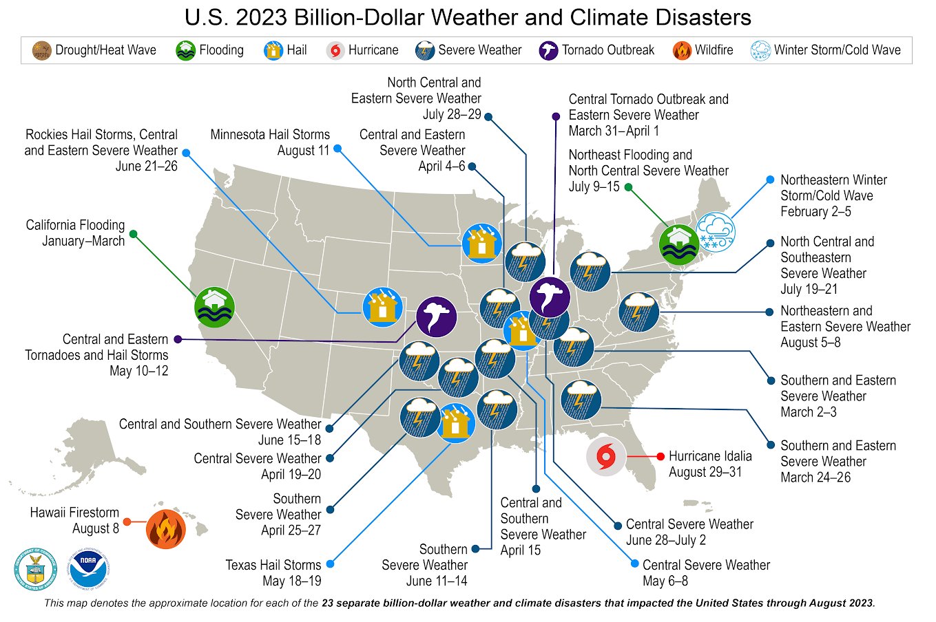 |
| NOAA: "Nation struck by all-time highest number of billion-dollar disasters" |
Sunday, August 27, 2023
Hurricane Franklin continues out in the Atlantic
 |
| Hurricane Franklin continues out in the Atlantic |
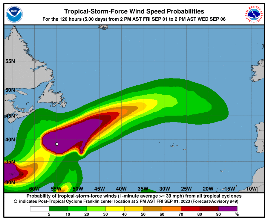 |
| Wind Speed Probabilities for Hurricane Franklin |
Wednesday, August 23, 2023
Tropical Storm Franklin, 1 of 4 being tracked
"...FRANKLIN NEAR THE SOUTH COAST OF THE DOMINICAN REPUBLIC.. ...HEAVY RAINFALL AND POTENTIALLY LIFE-THREATENING FLASH FLOODING LIKELY OVER HISPANIOLA...
As of 5:00 AM EDT Wed Aug 23
the center of Franklin was located near 17.4, -71.3
with movement N at 10 mph.
The minimum central pressure was 1000 mb
with maximum sustained winds of about 50 mph."
 |
| Tropical Storm Franklin, 1 of 4 being tracked |
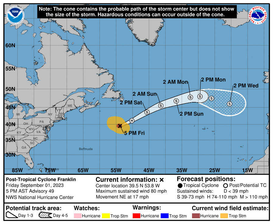 |
| TROPICAL STORM FRANKLIN - as of 8/23/23 - 8 AM Eastern |
Tuesday, July 11, 2023
Hurricane preparations from the NWS Boston
"Hurricanes never happen in New England, right? WRONG!
Today (Monday) is the kickoff to Hurricane Preparedness Week! Now is the time to prepare.
Check out this video to learn more!" 🌀https://t.co/zSmMdMZdkn
Shared from -> https://twitter.com/NWSBoston/status/1678403701818667008
Thursday, June 1, 2023
"Franklin" is one of the Hurricane names for the 2023 Hurricane season
 |
| "Franklin" is one of the Hurricane names for the 2023 Hurricane season |
Saturday, May 27, 2023
NOAA predicts a near-normal 2023 Atlantic hurricane season
"The Atlantic hurricane season will bring an average number of ocean storms and hurricanes this year, the National Oceanic and Atmospheric Administration (Noaa) said on Thursday.Noaa forecasters estimate 12 to 17 named storms of which five to nine of those will develop into hurricanes and one to four will become major hurricanes during the 1 June to 30 November season.The guidance came as experts considered the possible impacts this year of the El Niño weather system, which can dampen hurricane activity, and increasingly warm ocean temperatures, which can make storms more powerful.“What it boils down to is: which is going to win or do they just cancel each other out and you end up with a near-normal season?” said Colorado State University hurricane researcher Phil Klotzbach. “I respect them both.”
"NOAA forecasters with the Climate Prediction Center, a division of the National Weather Service, predict near-normal hurricane activity in the Atlantic this year. NOAA’s outlook for the 2023 Atlantic hurricane season, which goes from June 1 to November 30, predicts a 40% chance of a near-normal season, a 30% chance of an above-normal season and a 30% chance of a below-normal season.NOAA is forecasting a range of 12 to 17 total named storms (winds of 39 mph or higher). Of those, 5 to 9 could become hurricanes (winds of 74 mph or higher), including 1 to 4 major hurricanes (category 3, 4 or 5; with winds of 111 mph or higher). NOAA has a 70% confidence in these ranges."
https://www.noaa.gov/news-release/2023-atlantic-hurricane-season-outlook
 |
| A summary infographic showing hurricane season probability and numbers of named storms predicted from NOAA's 2023 Atlantic Hurricane Season Outlook. (Image credit: NOAA) |
Thursday, May 26, 2022
Atlantic #HurricaneSeason Outlook 2022 - above average active season forecast
Atlantic #HurricaneSeason Outlook 2022: 70% likelihood of 14-21 named storms of which 6-10 could become hurricanes, including 3-6 major hurricanes: http://bit.ly/2022AtlanticHurricaneSeasonOutlook… #HurricaneOutlook
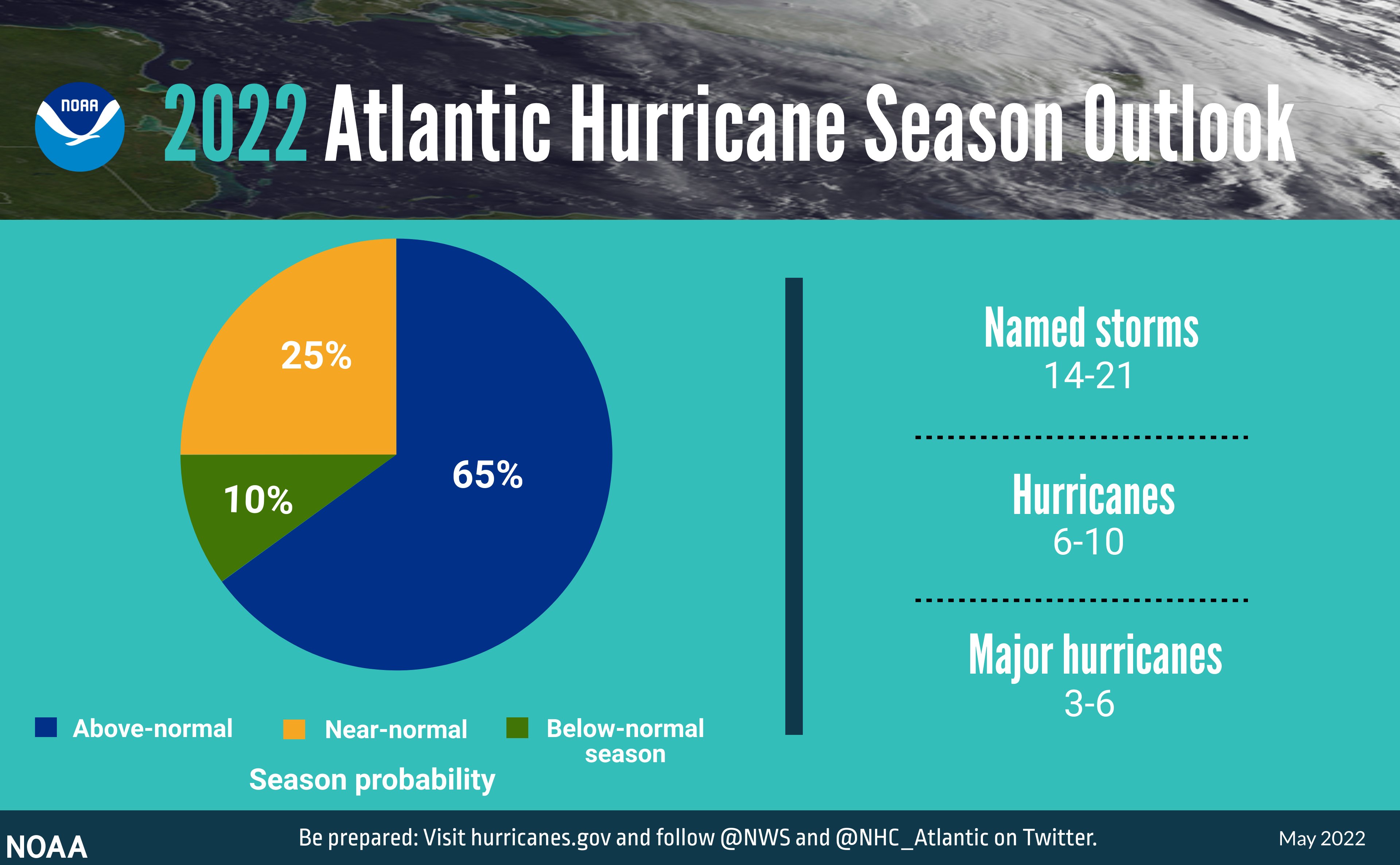 |
| Atlantic #HurricaneSeason Outlook 2022 |
 |
| hurricane name listing for 2022 |
Thursday, August 19, 2021
Tropical Storm Henri heads for New England, stay tuned for changes in the forecast
"Keep an eye on this one. The National Hurricane Center says the expected track of Tropical Storm Henri has shifted, meaning it’s more likely it will hit the Northeastern states at the end of the week.“The forecast track of Henri has shifted toward the northeast coast of the U.S. this weekend and early next week, increasing the risk of direct storm surge, wind, and rain impacts in portions of the northeastern U.S. and Atlantic Canada during that time,” the forecasters said Wednesday , noting that Henri was on the verge of reaching hurricane strength. “Interests in these areas should closely follow the progress of Henri and check for updates to the forecast.”
 |
| Tropical Storm Henri heads for New England |
Sunday, May 16, 2021
National Weather Service readies for the 2021 hurricane season. Are we ready?
The weather is so nice and warm, after being confined indoor for winter (and due to COVID=19) it is about time we could enjoy it. Did you know that hurricane season officially starts soon? Alerts started on May 15. The season officially opens June 1.
Sign up for alerts from the National Weather Service (NWS) https://www.nhc.noaa.gov/
Additional info on service enhancements for this season as well as info on the social media accounts to track https://www.nhc.noaa.gov/pdf/NHC_new_products_services_2021.pdf
"Today, May 15th, marks the first day of routine issuance of the
Atlantic basin Tropical Weather Outlook in 2021. This product
describes significant areas of disturbed weather and their potential for tropical cyclone formation during the next five days. The Tropical Weather Outlook is issued from May 15 through November 30 each year. The issuance times of this product are 2 AM, 8 AM, 2 AM, and 8 PM EDT. After the change to standard time in November, the issuance times are 1 AM, 7 AM, 1 PM, and 7 PM EST.
A Special Tropical Weather Outlook will be issued to provide
updates, as necessary, in between the regularly scheduled issuances of the Tropical Weather Outlook. Special Tropical Weather Outlooks will be issued under the same WMO and AWIPS headers as the regular Tropical Weather Outlooks.
A graphical version of the Tropical Weather Outlook is available on the web at: https://www.hurricanes.gov."
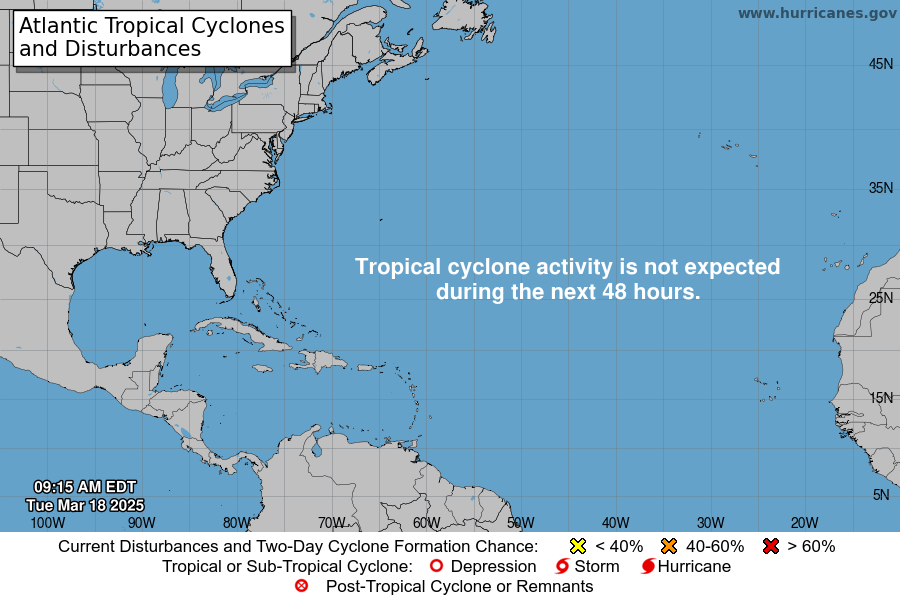 |
| There are no tropical cyclones in the Atlantic at this time. |
Wednesday, August 26, 2020
Remains of Hurricane Laura affect New England weekend
The weekend could be wet and windy with the remains of Hurricane Laura eventually making it's way here. We can use the rain!
Follow the progress of this storm via the National Hurricane Center https://www.nhc.noaa.gov/
 |
| NOAA Laura Storm track |
 |
| NOAA Laura Storm track - Weds AM |
Monday, August 3, 2020
NOAA info on Isaias
Get additional updates from NOAA here
https://www.nhc.noaa.gov/refresh/graphics_at4+shtml/092753.shtml?cone
Hurricane preparedness info
https://www.weather.gov/wrn/hurricane-preparedness
Stay tuned to your normal weather station for updates.
 |
| NOAA info on Isaias |
 |
| if it maintains this track, Western MA will get more of the rain than we will |

